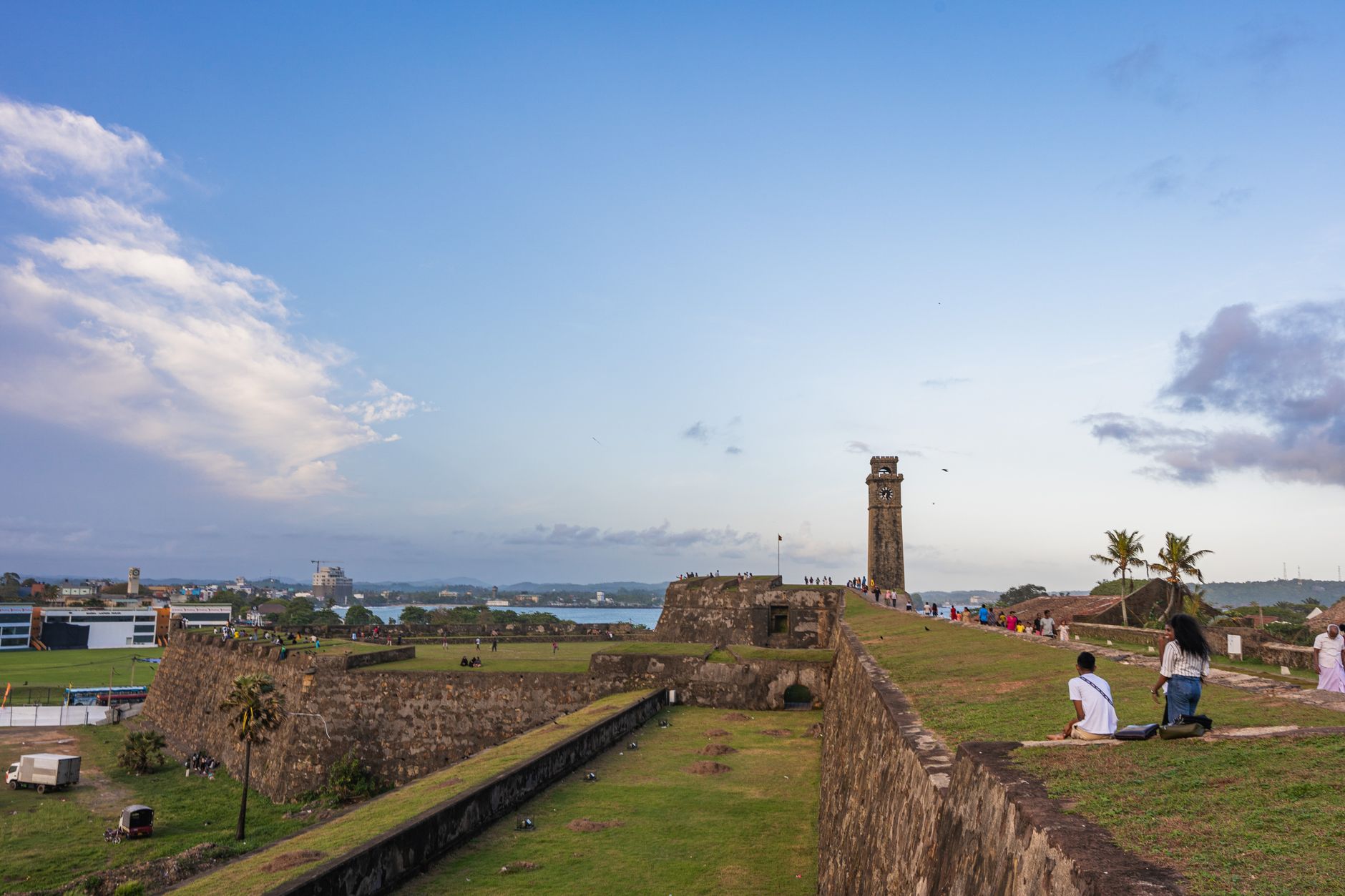
Old Galle Fort: Sri Lanka's Best-Preserved Colonial Fortress
Old Galle Fort is Sri Lanka's most complete surviving colonial fortification. Built by the Portuguese (1588), expanded by the Dutch (1663–1707), and strengthened by the British, its 36-metre-high ramparts encircle 52 hectares of living town. You'll walk genuine 17th-century bastions, colonial-era streets lined with working shops and temples, and encounter locals going about daily business—not a theme-park reconstruction.
The fort survived the 2004 tsunami largely intact (the seawall absorbed most impact), and today it's a UNESCO World Heritage site where residents actually live, work, and worship.
What makes Old Galle unique?
Unlike many fortresses converted to museums, Galle Fort functions as an inhabited town. You'll see:
Related: Fairway Colombo: Sri Lanka's Premier Golf Destination
Related: Is Siyambalanduwa Worth Visiting? An Honest Take
Related: Ayurveda in Sri Lanka: Retreat Experiences and Practical Guide
- The ramparts: 1.4 km of continuous walkable walls with bastions named after Dutch governors (Clippenburg, Magere, Amsterdam, Zwart). Views sweep across the Indian Ocean and inner fort.
- Colonial grid streets: Church Street (the main thoroughfare), Pedlar Street, Middle Street—lined with corrugated-iron shopfronts, Buddhist temples, Hindu shrines, and colonial-era buildings repurposed as cafés and galleries.
- The courthouse (1873): Victorian Gothic structure still in use, visible from Church Street.
- The lighthouse (1848): A functional, working beacon on the southern ramparts—plain white tower, remarkable views from the base.
- The Dutch Reformed Church (1755): Plain Protestant interior, whitewashed walls, atmospheric at dusk.
- Galle International Cricket Stadium: Sits just outside the fort walls; you can sometimes hear matches from the ramparts.
Best time to visit Old Galle
March to April & August to September: Dry spells with manageable crowds. Rampart walks are comfortable early morning (6–7 a.m.) or late afternoon (4–5 p.m.).
May to September (southwest monsoon): Afternoon rains can arrive suddenly; the ramparts become slippery. Morning walks remain feasible.
December to February: Peak season—busy with tourists, especially weekends. Ramparts are crowded by 9 a.m., but sea conditions are calmest.
October to November (northeast monsoon): Rain-heavy, least crowded. The fort's interior remains walkable.
Avoid weekends (Saturday-Sunday) if you want space; locals flock to the ramparts mid-morning.
How to walk the ramparts properly
The 1.4 km perimeter takes 45–60 minutes depending on pace and stops. Enter from the Main Gate (eastern entrance, near the carpark and buses). The walk is mostly flat but uneven—wear trainers with good grip.
Recommended circuit (clockwise from Main Gate):
- Main Gate to Clippenburg Bastion (northeast): Rampart widens here; town sprawls below. British cannons remain mounted.
- Clippenburg to Magere Bastion (northwest): Best sunrise views; faces the ocean directly. Locals fish from rocks below at dawn.
- Magere to Amsterdam Bastion (southwest): Passes over the carpark, less scenic.
- Amsterdam to Zwart Bastion (south): The lighthouse sits here. Most dramatic seaward drop. Early morning light is golden; afternoon glare reflects off the sea.
- Zwart back to Main Gate (east): The return stretch passes the cricket stadium and inner-town rooftops.
Traverse slowly. Stop at each bastion. The sea-level detail changes—you'll notice fishing boats, spice warehouses (some still active), tide patterns.
Inside the fort: streets and structures
Church Street (the spine): Broadest, busiest, café-dense. Head here for coffee and orientation, not for atmosphere.
Pedlar Street (southern): Quieter, lined with fabric shops and jewellers still serving locals.
Middle Street (central): Narrow, shopfronts at shoulder height, temple bells echo. Most photogenic in early light.
The Japanese Peace Pagoda area (northeast): Built 1990s by Japanese Buddhist monks; jarring architectural contrast but peaceful, with views toward the outer moat.
Star Bastion (northwest corner): Largest bastion, used for colonial gatherings. Odd angles and asymmetrical walls reflect 17th-century military design. Stand in the centre; the acoustic geometry amplifies sound strangely.
Practical details
Entry: Free to walk the ramparts and streets (no gate control); some buildings (lighthouse, specific structures) may charge small fees.
Duration: 2–3 hours minimum for ramparts and a wander; half-day if exploring museums and cafés.
Facilities: Limited water fountains; buy bottled water in town. Few formal toilets; use café facilities if purchasing.
Guides: Licensed guides wait at the Main Gate. Useful for specific history, but the physical fort speaks for itself; skip unless deeply interested in construction dates.
Photography: Dawn light hits ramparts from the east; sunset glows from the west seawall. Afternoon light is harsh.
Galle town beyond the fort
The modern town spreads south and east. The Galle Face Green (outside the fort's eastern wall) is where locals gather at dusk—no tourist infrastructure, authentic Sri Lankan seaside life. The fish market (early morning, southern approach to town) is visceral and working; nets hang from poles, ice water runs, haggling is real.
Stay in Galle town for sunset and evening; the fort empties by 5 p.m., and walking the ramparts under dusk light—few people, salt air, lighthouse beam starting—is when the place feels genuinely historical rather than visited.
How does Galle compare to other Sri Lankan forts?
vs. Jaffna Fort: Jaffna is larger, still heavily militarised, less accessible to visitors; Galle is civilian, navigable, complete.
vs. Matara Fort: Matara (20 km north) is smaller, less intact, fewer facilities; worth a brief stop if heading to Unawatuna beach, but Galle's ramparts and town are superior.
vs. international comparisons: Dubrovnik (Croatia) or Cartagena (Colombia) are comparable in scale and tourist infrastructure, but Galle is less developed—cheaper, less crowded, more functional as a living town.
Nearby: extend your visit
If heading to or from Galle, consider:
- Unawatuna beach: 5 km north, 15 minutes by taxi. Crescent bay, calm water, beach restaurants. An hour there merges well with a fort morning.
- Mirissa: 15 km west, whale-watching centre (November–April). Half-day combination possible.
- Ella: 4–5 hours inland by train or car. Cooler highland alternative.
FAQ
Can you swim from Galle Fort's outer walls?
Technically yes, but the seabed is rocky, currents shift with tide, and locals advise against it. Unawatuna bay, 5 km north, is far safer for swimming.
Is the 2004 tsunami visible in the fort today?
Not dramatically. The seawall absorbed impact; some reconstruction on the northeastern rampart occurred post-tsunami, but it blends visually. Museum displays in Colombo document damage better than the fort itself.
How long can you realistically spend in Galle?
Ramparts and streets: 2–3 hours. With a meal, a museum visit, and lingering: 4–5 hours. A full day (overnight stay) lets you see dawn and dusk light, which fundamentally changes how the fort reads.
Is there a ticket office or entry fee?
No formal entry system exists; the fort is open. Small donations are suggested at certain temples inside. Parking (near Main Gate) costs ~200 LKR. Consider it essentially free access—rare among Asian heritage sites of this scale.